

Şu anda adlı kullanıcıyı takip ediyorsunuz
Kullanıcıyı takip etmede hata.
Bu kullanıcı kullanıcıların kendisini takip etmesine izin vermiyor.
Zaten bu kullanıcıyı takip ediyorsunuz.
Üyelik planınız sadece 0 takibe izin veriyor. Buradan yükseltme yapın.
başarılı bir şekilde takipten çıkarıldı
Kullanıcının takip edilmesinde hata.
adlı kullanıcıyı başarılı bir şekilde tavsiye ettiniz
Kullanıcıyı tavsiye etmede hata.
Bir şeyler yanlış gitti. Lütfen sayfayı yenileyin ve tekrar deneyin.
E-posta başarılı bir şekilde doğrulandı.

lahore,
pakistan
Şu anda burada saat 8:55 ÖÖ
Temmuz 13, 2017 tarihinde katıldı
0 Öneriler
Muneeb A.
@MUNEEBAAMIR
0,0
0,0
0%
0%
lahore,
pakistan
Mevcut değil
Tamamlanmış İş
Mevcut değil
Bütçe Dahilinde
Mevcut değil
Zamanında
Mevcut değil
Tekrar İşe Alınma Oranı
Geospatial Expert
Muneeb A. ile işiniz hakkında iletişime geçin
Detayları sohbet üzerinden tartışmak için giriş yapın.
Portföy
Portföy


Preparation of Digital Elevation Model
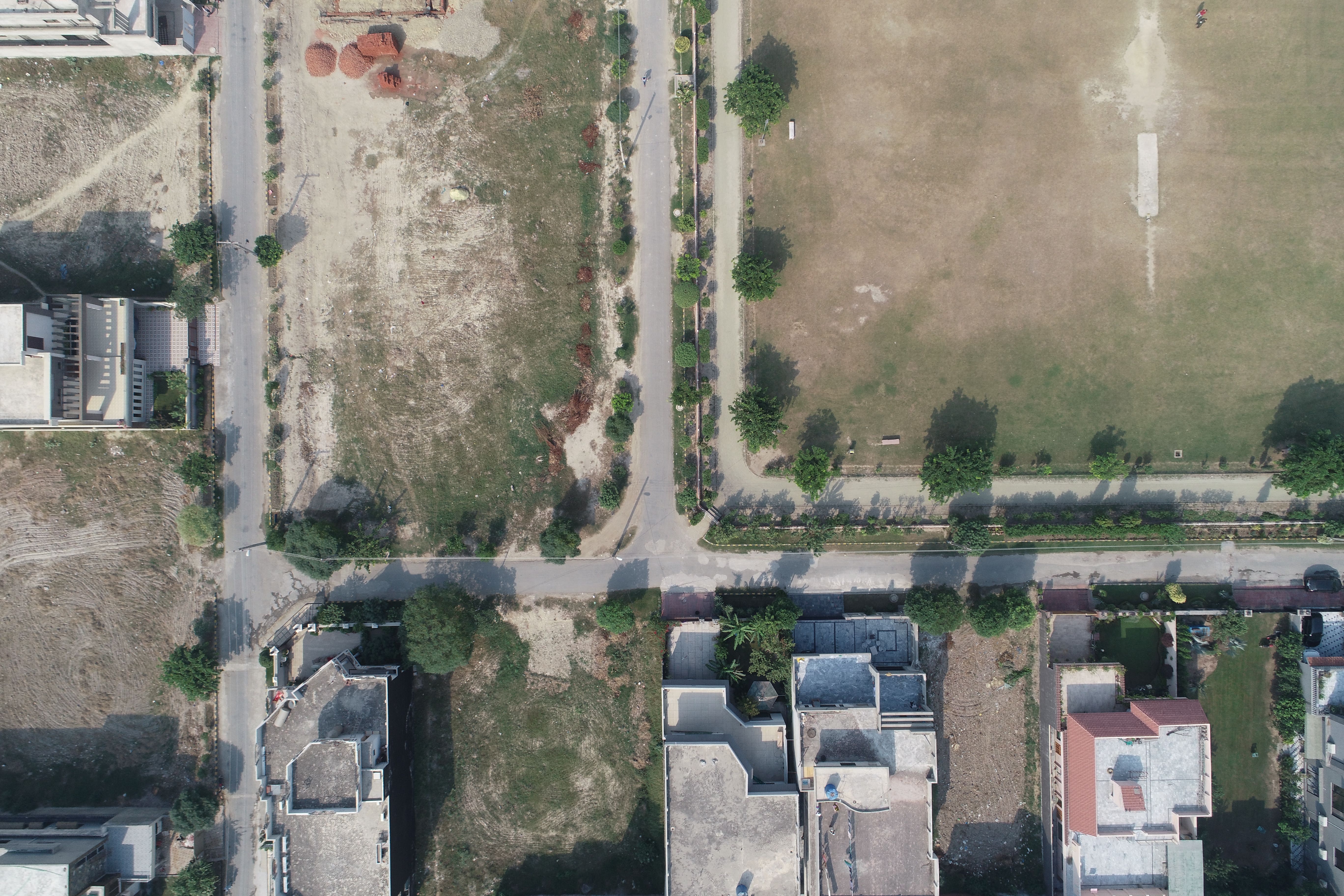

Drone Mapping

Drone Mapping

Drone Mapping
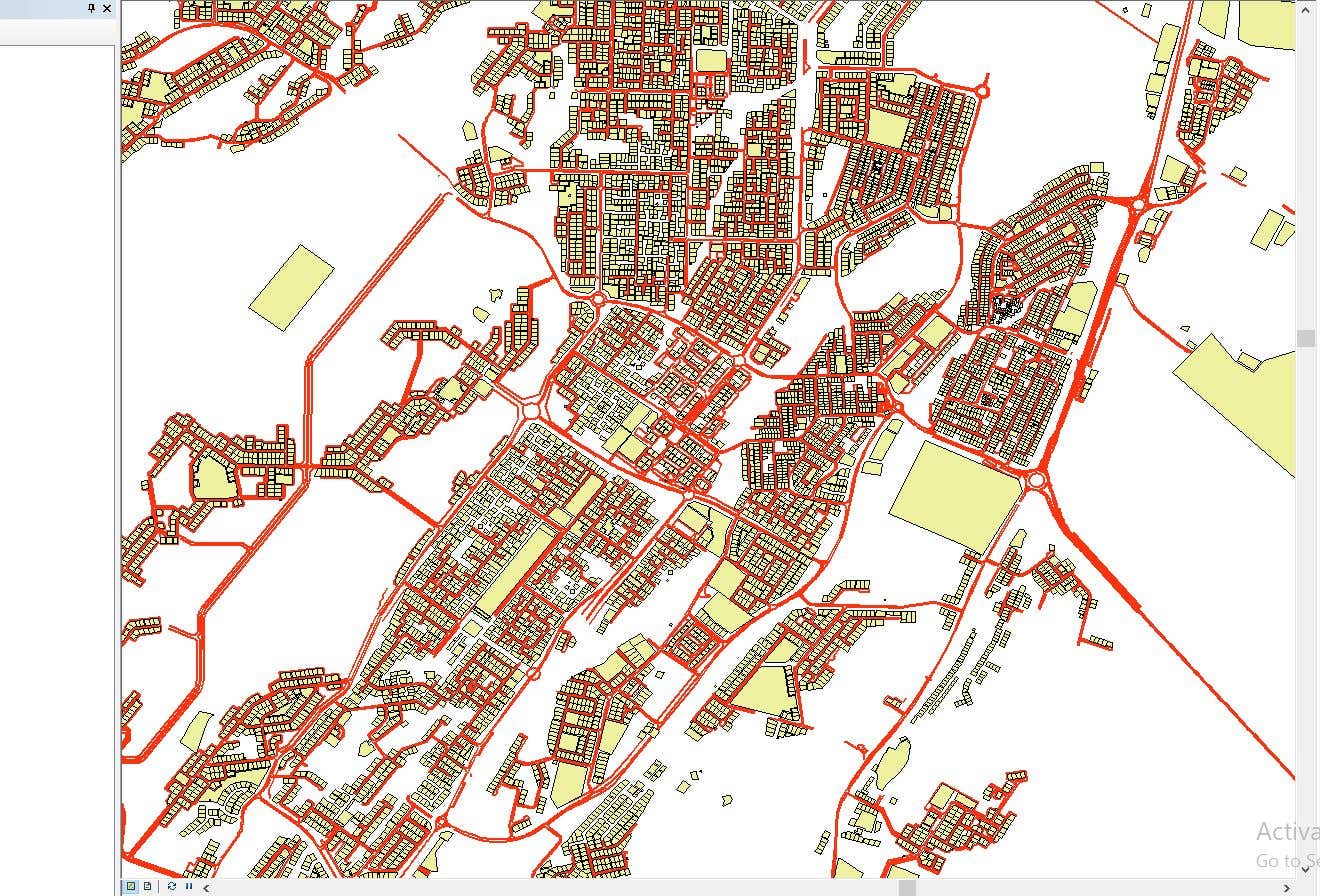

CAD to SHP Files

CAD to SHP Files
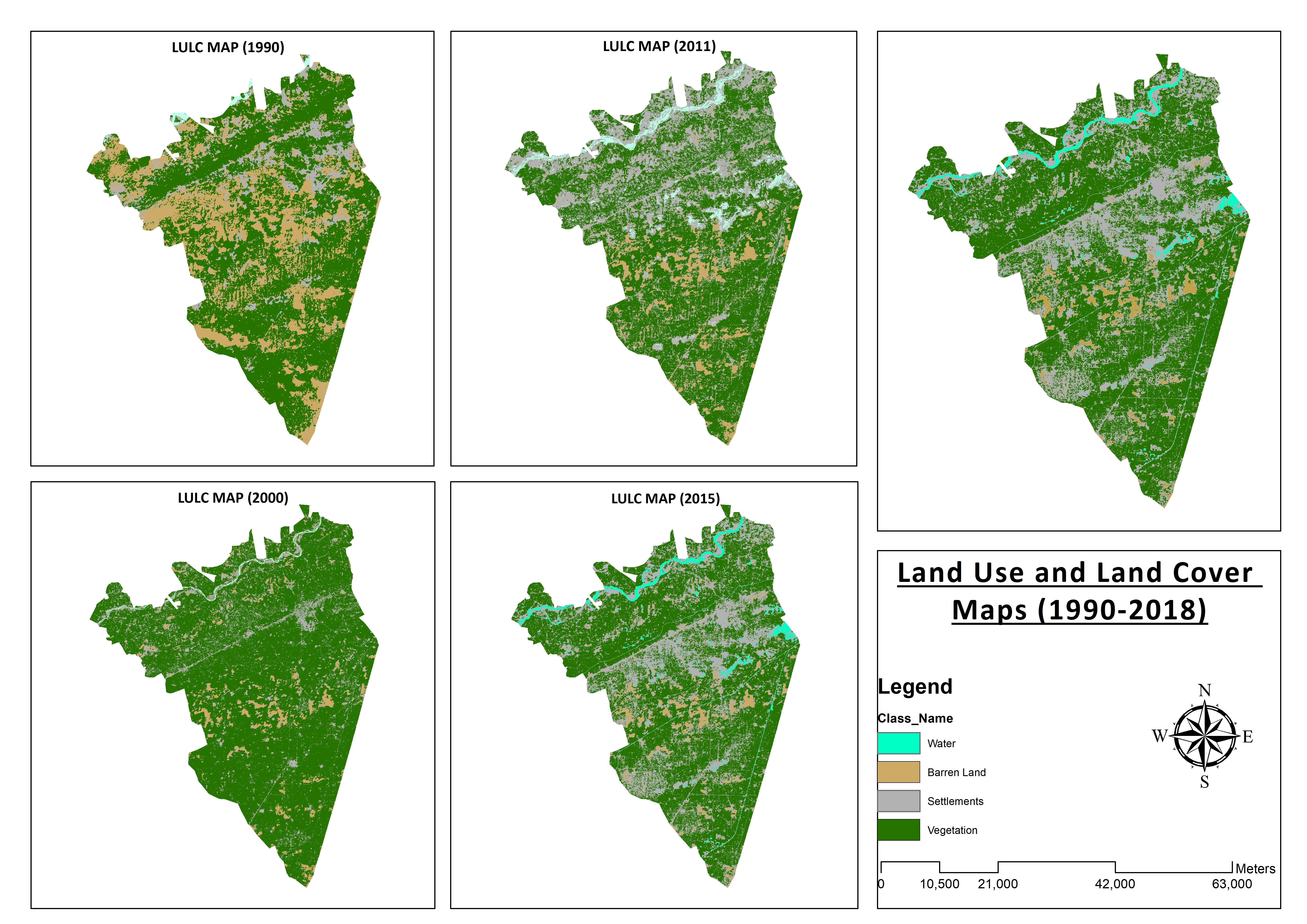

Land Use and Land Cover Maps
Preparation of Digital Elevation Model
Drone Mapping
Drone Mapping
Drone Mapping
CAD to SHP Files
CAD to SHP Files
Land Use and Land Cover Maps
Değerlendirmeler
Değişiklikler kaydedildi
Burada görülecek hiç değerlendirme yok!
Deneyim
Remote Sensing and GIS Analyst
Eyl 2018 - Eki 2019 (1 yıl, 1 ay)
Developed, integrated and Implemented GIS and Geodesy based Topographic Survey Plans under different Hydro-Power Projects in Northern Pakistan, Extension of Canal Projects to increase its capacity in Sindh-Balochistan, Analysis of Suitable Site Selection for different development sites by using Drone for Aerial Mapping and their detailed pre-feasibility studies with different softwares, to analyse and interpret spatial data to produce interacting Maps and Reports while ensuring quality control.
Research Associate GIS
Eki 2015 - Eki 2018 (3 yıl)
Deployed GIS-based system under Urban Immovable Property Tax (UIPT) for Punjab Excise & Taxation Department. Provided comprehensive support in creating the system while take advantage of software suites like ArcGIS Suite and ERDAS Imagine. Prepared communicating maps to help surveyors in Analyzing geo-spatial data to verify it during ground truthing. Created shapefiles to merge topographical data with external data through layering process.
Eğitim
Master of Philosophy in Geographic Information System
(2 yıl)
Bachelors in Geographic Information System
(4 yıl)
Nitelikler
MS-Office
TEVTA
2017
MS-Office Certification in MS-Word, Excel and Power Point.
Yayınlar
Analysis of Flood Damage Assessment through Different Satellite Datasets in Southern Punjab,Pakistan
International Journal of Innovations in Science & Technology
RS and GIS techniques can achieve the objectives and significant analyses through visual interpretations. These techniques are also used to identify the flood affected regions. The study site was examined by applying supervised classification determining that 16900.96 Hectors of agriculture land was damaged while Sparse Riverine Forest had the area 44.52 hectors. The damaged built-up area was 1805.78 Hectors.
Estimation of Net Rice Production by Remote Sensing and Multi Source Datasets
Sarhad Journal Of Agriculture
Estimation of net crop production before harvest enables agronomists and decision makers to determine the volume of grain precisely. Yield estimation is one of the challenging tasks which is significant to evaluate accurately for farmers. This research was conducted in eastern Punjab Pakistan by incorporating yield/area as reported by Crop Reporting Service Department along with open source satellite datasets.
Muneeb A. ile işiniz hakkında iletişime geçin
Detayları sohbet üzerinden tartışmak için giriş yapın.
Doğrulamalar
Önde Gelen Beceriler
Benzer Freelancerlara Göz Atın
Benzer Vitrinlere Göz Atın
Davet başarılı bir şekilde gönderildi!
Teşekkürler! Ücretsiz kredinizi talep etmeniz için size bir bağlantı gönderdik.
E-postanız gönderilirken bir şeyler yanlış gitti. Lütfen tekrar deneyin.
Panoya kopyalama başarısız, lütfen izinlerinizi düzenledikten sonra tekrar deneyin.
Panoya kopyalandı.
Ön izleme yükleniyor
Coğrafik konum için izin verildi.
Giriş oturumunuzun süresi doldu ve çıkış yaptınız. Lütfen tekrar giriş yapın.